The arrival of Hurricane Lee (a Tropical Storm) as a new performer on the stage of the natural forces comes as we find ourselves in the middle of the Atlantic hurricane season. Lee, which began as a tiny tropical depression, has become surprisingly strong and is on course to become a hurricane. In this blog post I’ll examine Lee’s development from a slight depression to what might eventually become a strong Category 4 hurricane. I’ll also discuss how this hurricane might affect people’s lives and different sectors of the country.
The Birth of Tropical Storm Lee
Tropical Depression 13 emerged on a Tuesday morning, lurking in the central tropical Atlantic, almost 1,000 miles west-southwest of the Cabo Verde Islands, as reported by the National Hurricane Center. This depression marked the first step in what would soon become a meteorological spectacle.
From Humble Depression to Powerful Storm
In a matter of hours, the depression transformed into Tropical Storm Lee. The National Hurricane Center’s 5 p.m. update on Tuesday confirmed this development, as Lee began to gather momentum. The intriguing part was that Lee’s story was far from over – it was just beginning.
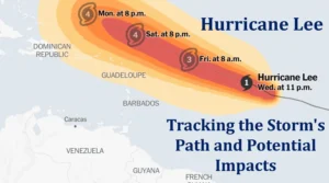
With winds clocking in at 45 mph and steadily moving west-northwest at 16 mph, Tropical Storm Lee began capturing the attention of meteorologists. The buzz was about Lee’s promising future – forecasts projected it to grow into a major hurricane by Friday, with the potential to reach the fearsome Category 4 status by Saturday.
The Science Behind Lee’s Power
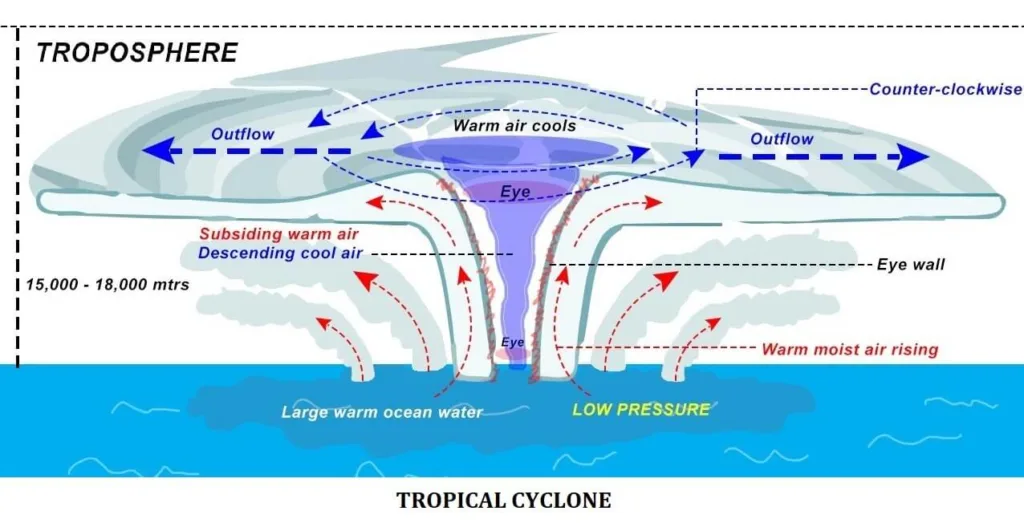
Understanding why Lee grew so fast is really important. Lee will travel through progressively favorable circumstances for strengthening as it keeps on its west-northwest course. Moisture, little wind shear and unusually warm seas are the ideal combination for this developing storm. A hurricane forms through a complex process that involves several key factors. They are as follows:
Warm Ocean Water
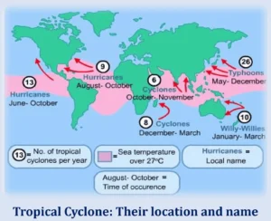
Hurricanes begin over warm ocean waters, typically when the sea surface temperature is at least 80 degrees Fahrenheit (27 degrees Celsius). Warm water is necessary as it provide the required heat and moisture for the storm to form.
Evaporation
The warm water causes evaporation, where water vapor rises into the air. This moist air becomes the primary source of energy for the hurricane.
Low-Pressure Area
A disturbance in the atmosphere, like a cluster of thunderstorms or a weather front, creates a low-pressure area. Low pressure is a crucial ingredient for hurricane formation.
Rising Air
The low-pressure system causes the air near the surface to rise. The rising air cools and condenses to form clouds.

Formation of a Tropical Depression
If the conditions are favorable and the system continues to strengthen, it can develop into a tropical depression. At this stage, winds are less than 39 mph (63 km/h).
Becoming a Tropical Storm
If the tropical depression continues to organize and winds reach speeds between 39 and 73 mph (63 to 118 km/h), it becomes a tropical storm. It’s given a name at this point.
Developing into a Hurricane
When the tropical storm further intensifies, with wind speeds exceeding 74 mph (119 km/h), it is classified as a hurricane. Hurricanes are categorized from Category 1 (weakest) to Category 5 (strongest) based on their sustained wind speeds. Hurricanes are the name of tropical cyclones in the Atlantic Ocean along with Eastern and Central Pacific Ocean. Whereas in western Pacific it is known as Typhoon. In the India and Indian Ocean region it is called Cyclone and in Australia it is referred as Willy-Willy.

Eye Formation
A well-developed hurricane features a calm, clear center known as the eye, surrounded by a ring of intense thunderstorms called the eyewall.
Ongoing Energy Source
As long as the hurricane remains over warm water and encounters minimal wind shear (changes in wind speed and direction with altitude). It can continue to draw in heat and moisture, allowing it to grow and maintain its strength.
Landfall or Dissipation
A hurricane can either make landfall, where it can cause significant damage or weaken and dissipate as it moves over cooler waters or encounters unfavorable atmospheric conditions.
Hurricanes Can Be Hard to Predict
It’s important to note that hurricane formation is a natural meteorological process and scientists closely monitor and track these storms to provide early warnings and protect communities in their path. Weather experts are a bit puzzled by the path of Hurricane Lee. Usually, they’re careful with early predictions but this time, the National Hurricane Center seems pretty confident that Lee will become a strong hurricane.
Hurricane Lee’s Impacts and Current Status
The 2023 Atlantic hurricane season will be more complicated as a result of Lee’s transition into a hurricane. This season has already been tracking above normal for named storms, hurricanes and major hurricanes, highlighting the necessity of careful monitoring.
On Wednesday evening, a big upgrade came when Tropical Storm Lee outperformed forecasts and intensified into a Category 1 hurricane with top sustained winds of around 80 mph. The storm could keep getting stronger and become a Category 4 hurricane as it moves over the warm Atlantic waters.
Hurricane Lee’s Path Forward
As we examine Lee’s current course, it is clear that the storm is moving west-northwest at about 14 mph, with a slight reduction in forward speed anticipated over the weekend. With this course, Hurricane Lee will be in a position to pass quite closely over Puerto Rico and the northern Leeward Islands.
Preparing for Impact and Safety Measures
Areas that might be affected by Hurricane Lee need to prepare for what could be a significant weekend. The Leeward Islands and the U.S. Virgin Islands will need to take more precautions. Because they are situated at the confluence of the western Atlantic Ocean and the Caribbean Sea converge.
While Hurricane Lee’s impact on the U.S. mainland remains uncertain, coastal regions along the East Coast should not let their guard down. Dangerous surf and rip currents pose a potential threat, necessitating precautionary measures.
Florida’s Relief and Recovery
Florida, still recovering from the recent encounter with Hurricane Idalia, is fortunate that Hurricane Lee is not currently forecasted to impact its shores. Weather specialists are continuously keeping an eye on the trajectory of the Lee. Afterall, it becomes the prime responsibility of these weather experts to ensure the safety of the population.
Importance of Spaghetti Model
A group of computer-generated weather forecast models known as spaghetti models aid meteorologists in predicting the many courses that a storm or hurricane may take. These models display multiple lines or “spaghetti strands,” each representing a different computer model’s projection of the storm’s track. Additionally, Meteorologists can figure out where a storm might go by looking at these different paths. It also helps them to understand all the possible routes which the hurricane can take. Thus, enables them to issue warnings accordingly.
Results yet to come from Hurricane Lee
From the past few years there has been a frequent increase in the occurrence of tropical cyclones, and this is one of the outcomes of Global Warming. As Tropical Storm Lee evolves into a hurricane, its journey is far from over. However, timeline of Lee highlights how unpredictable the hurricanes are. Moreover, it becomes important that the regions which are prone to the landfall of such hurricanes are well prepared from such natural disasters. Everyone must be thankful to the meteorologists for their services. As they are continuously monitoring and issuing warning according to the developments taking place in the path of the hurricane. Let’s collectively pray to the Almighty for the weakening of the Lee and reduce impact of the hurricane on the humanity and on US.
